Trail number
Not applicable
Trail length
20 kms return
Elevation variance
500 metres
Trail type
Single trail, fire trail and gravel road
Trail surface
Gravel, rock outcrops and rocks
Weather affected
Prone to be muddy after heavy rain
Trail condition sources
Nil
Trail features
Suitable for 4WD shuttle to top. Massive 500 metre drop in 4 kms.
Trail obstacles
Legs being able to last.

Trail rating
Difficult
Rating basis
Estimated
Night riding
No
Family Friendly
No.

Use Topographic Map For This Area
No GPX download
From near the Fry's Flat area, you can follow the Howqua Hills Track over to Tobacco Flat. This is a 2WD road that can be readily covered by a mountain bike.
From here, if you keep following the Howqua Hills Track it rapidly ascends as a 4WD only track. This track is reasonably chewed up by the 4WDs due to the steepness which make it interesting. If you keep going up the 4WD track you get good views across to Buller. Please note that this is a seriously steep bit of track with an average gradient of 1 in 8 so don't be surprised if you walk a reasonable amount of it! If you've got a 4WD buddy, do a shuttle run up.
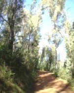
Pictures below are of the 2WD portion to Tobacco Flat and the second photo is from the 4WD portion looking down on to Tobacco Flat.
The trail is shown in blue in the map above.
 |
 |
|---|---|
View over Tobacco Flat and 4WD portion of track. |
|
No video available for this trail.
 |
Parking is available at Tobacco Flat. |
|---|---|
 |
No toilet facilities are available. |
 |
No drinking water is available. |
 |
No food or drinks are available in the immediate area. |
 |
No local information facilities are available. |