
Probably one of my first trips to Blackwood back in 1964.
I've had a long association with Blackwood as our family having owned a holiday house up there during my childhood and youth. The area is a great little place to explore with lots of history and natural features hidden away in the surrounding forests.
In my earlier times, the whole area around Blackwood was criss crossed with lots of 4WD and motorbike tracks, had the odd mine still operating and the timber industry used to regularly clear fell large chunks of the forest.
Luckily this has changed to a large degree with the area to the south east now a conservation area based around the beautiful Lerderderg Gorge. To the other sides of Blackwood, there is the Wombat State Forest which remains open to to the public for 4WDing and dirt bike riding and the more sedate activities such as hiking, fossicking and gradually mountain biking is becoming a bit more popular.
The area is most famous for the discovery of gold in 1854 at Jackson's Gully and for the timber industry which operated from that period up until fairly recently. The timber industry has also largely been stopped in the area and so the forest is gradually recovering to be a fully forested area again.
So what are the areas of interest around Blackwood? Well here are a few ideas from around the township and out in the bush which you can explore at your leisure..
Most of the photos below are used with the permission of Travel Victoria (marked with an asterisk) with the remainder being provided by Bancoora.com.

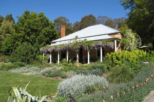
View from Byres Road down to township - pub on right. *
The township has a number of old buildings from the gold rush era which remain to this day. The Blackwood Pub is the oldest weatherboard pub which has maintained a continuous licence and was built in 1856.
Of a similar era are the three churches on the hill above the town - one Uniting, one Anglican and one Catholic. These are all just celebrating their 150 year anniversaries.
Also in town is the Blackwood Merchant which is located in the old general store / post office. The two Simons and staff will look after you for that post ride meal and drinks.
There are a limited number of accommodation options in town which can be found by searching the web as well as the caravan park which is located at the Mineral Springs Reserve.
There are a number of old buildings in the town such as Blackwood House and the Bric a Brac store. The latter was Lerdies Restaurant for many years before eating out became really popular - I'm not really too sure how it survived back then but it did. Prior to this in the gold rush era, this building housed the National Bank of Australasia. You can read about its history in this copy of the Blackwood News.
There are a number of old miners huts around the town as well. My grandfather used to regularly take me for walks all around Blackwood and Charlie Hill (a descendant of Edward Hill who discovered gold in the area) was still living in the miners huts on the left of Simmons Reef Road at that time.

Cobb and Co Tearooms (currently closed) *
The other building of interest in town is the Cobb and Co tearooms (currently not operating as tearooms but believe it is being used for accommodation) which is where the Cobb and Co stage coaches used to stop in the mining era. You can still see the original wooden shingles under the tin roof in places.
Another interesting architectural feature of Blackwood are the log cabins. There are a number of them down in the Simmons Reef area near the Poveys Road area and a number of them in the Whalebone Road area as well.
If you wish to look at one, Baldy's hut is located on a hill behind the Garden of St Erth. It is on Quicks Road near the summit of the hill. You can access Quicks Road from Simmons Reef Road or by following the track behind the Garden of St Erth eastwards. It's a good little MTB detour on the way back from the Garden of St Erth to the recreation reserve if you've parked there.
The Recreation Reserve is located on Simmons Reef Road - head down the branch off to the right and follow it around. This recreation reserve is one of those little country grounds which has retained the old grandstand and it's a great little ground to take the kids for a kick of the football or soccer ball or a hit of cricket. Most times, you will have the ground to yourself. However, there are various events on during the year including cricket, woodchops, panning competitions, music festivals, etc.
The ground has been carved into the hillside and features a row of magnificent massive pine trees and these are on the heritage register. At 51 metres, these are seriously big pine trees and well worth a look.

Cemetery
The cemetery is located on Byers Road (head uphill past the churches from the pub and it's on the right). The Blackwood community has recently undertaken a regular maintenance program on the cemetery after being relatively overgrown in the '70s.
The highlight of the cemetery is the Rogers vault (see photo at left) which was built when Matthew Rogers' (owner and builder of the stone cottage "Garden of St Erth") wife died. At the time it cost £1000 to construct. It is adorned by a number of elaborate stone statues and is well worth a look. There's a lot of local history in the cemetery and you will see many names similar to street names, local features, etc for good reason.
Another feature that has recently been uncovered are the Chinese graves located on the downhill side of the cemetery near the fence line. In spite of my long association with Blackwood, I was completely unaware of them until the cemetery was better maintained.
The other thing you will notice is, like in a lot of other pioneer cemeteries, is the number of young children that died from disease showing how hard the environment must have been to live in. On a more recent sad note, Paul Hester the drummer from Spit Enz and Crowded House is also buried there.

Mine adit on Byers Back Track
As you'd expect in a mining town, there are numerous mine adits and shafts in the area. A lot have been caved or filled in over the years to make logging operations safer or used as rubbish tips as well. Having said that there are still numerous examples to be seen in the area.
If you have a GPS, here is a Google Earth .kml file with the locations of where all mines in the area are or were as the case may be. You can view these in Google Earth or transfer them into GPS .gpx format at GPS Vizualiser. This can be quite a good way to explore the areas history as you can come across major diggings and shafts in some very remote locations.
The Tyrconnel is one of the more recent mines that was operational and still has some of the infrastructure in place.
You can use these files to locate some of the old mines out in the bush. Obviously be careful in the vicinity of mines - the shafts can be very deep and the adits shouldn't be entered as they may not be stable. Further, you can get diggings that get covered with fallen trees, leaf litter, etc so the best advise is to make sure that you are always walking on solid ground and remain downhill of any shafts to avoid the possibility of sliding into one.
Here are some readily accessible mining features. At the mineral springs, follow the river upstream for a 100 metres or so and there is an adit for the Rip Van Winkle mine in the left bank near the water hole. At the western end of the Byers Back, wall in a short distance and there is an adit on the right side of the trail. At the Garden of St Erth, follow the Whipstick Loop trail and a short distance down there are a number adits on the right and a large shaft further around. Another good one if you've got a torch is to enter the St Erth car park and head out the western exit. You will end up entering a gravel road (Lerderderg Road). At the intersection and immediately on the right is a shaft that has been properly covered over with mesh so you can actually look down the shaft safely.
Garden of St Erth *
At the end of Simmons Reef Road is the Garden of St Erth which was named by its owner and builder after his home town in Cornwall. The owner Matthew Rogers had various mining interests in the area (including the Big Hill mine) and also ran shops in the Simmons Reef area.
The area surrounding the Garden of St Erth was a hive of mining activity at its peak with numerous shafts still present out on the Whipstick Loop walk. There were numerous water wheels and water races serving this area as well as a reservoir at one stage which was destroyed during a flood.
The Garden of St Erth is now run by the Diggers Club and has a cafe as well on the premises. The cafe area can be entered for free but they do charge an entry fee of about $10 for adults but, if you're interested in gardens, it's well worth visiting.

Mineral Springs *
The mineral springs are located just out of town on Golden Point Road. There is a small entry fee (about $2) for cars. There are two springs located in the reserve - one is a soda water spring and the one over the bridge is iron water.
Just upstream from the springs is a water hole which is good for a swim on a hot day - not overly deep so kids can go in there as well as long as you keep an eye on them.
You can either walk up to Shaws Lake from the mineral springs or drive. This is another good spot for a swim on a hot day. It's quite deep though so better for good swimmers.
Heading east on Golden Point Road there is also a water hole referred to locally as Sebastapol on the left after the road turns to gravel. This is good for a swim also and gradually goes from shallow water to deeper water on the opposite bank so is good for the whole family as long as kids don't stray into the deeper water
As you head west out of the Garden of St Erth car park, there is a piece of single track that heads up the hill A couple of hundred metres up the hill is a tree that unfortunately succumbed just a few years ago. This pine tree used to be the sole tree on the peak of the hill and was planted by the Simmons Reef school children in 1887 to celebrate the 50th Anniversary of Queen Victoria's coronation. It fell after living for almost 120 years. A number of pines have popped up to replace it since.
There are a number of walks in the area which include:
Whipstick Loop - The Whipstick Loop can be accessed from the Garden of St Erth or from a trailhead on the western side of Skinners Road and is well worth a walk. It varies from dry eucalypt forest to beautiful rain forest along the banks of Back Creek. The latter can have some beautiful mosses and absolutely spectacular fungi during the wetter months of the year. There are also the remains of a waterwheel foundation there if you keep your eyes open.
Mineral Springs - Across the bridge you can head off left which takes you up to Shaws Lake which was used to store water for sluicing and the water races during the mining era. Off to the right takes you along the GDT and follows the Lerderderg River to the west and is quite a pretty walk. The area on the right as you head west is where gold was first found in the area. There is a steep trail off to the left which takes you up to a lookout that looks out over Golden Point.
If you follow Golden Point Road out east from town until it hits the gravel and continue on you will reach a large "Lerderderg State Park" sign with a parking area near it. This is the start of the Byers Back Track which heads out to O'Briens Crossing. It passes Tunnel Point which is located at the base of Gribbles Track which intersects with Byers Back Track. This is well worth a look and is best viewed from the downstream end. The tunnel was dug to divert the river across a horse shoe shaped part of the river to allow access to alluvial gold. Unfortunately the upstream entry got filled with fallen trees during a recent flood which makes it hard to see properly currently.
The Great Divide Trail (GDT) runs from Daylesford to Bacchus Marsh and takes in some the trails listed above.